Helping the Visually Impaired Navigate Louisville Using Open Data
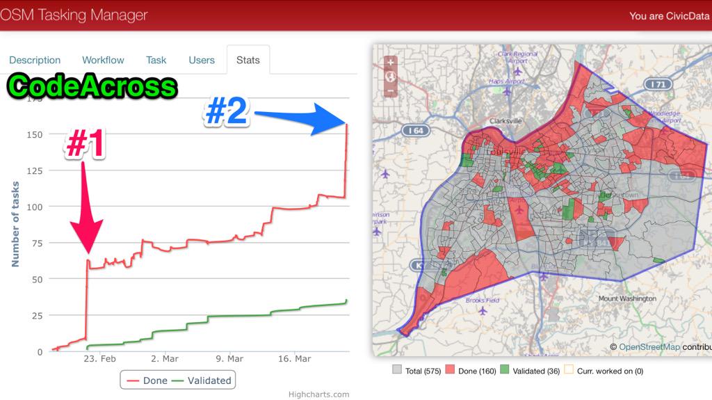
The CDA hosted two CodeAcross 2015 events in Louisville on February 21 and March 21. Dedicated volunteers converged on the Urban Design Studio and the American Printing House for the Blind for two days of OpenStreetMap learning and editing, in support of the American Printing House for the Blind’s ‘Nearby Explorer’ app. Nearby Explorer is an advanced GPS solution recently released for Android smartphones by the American Printing House for the blind. The app gives the visually impaired and the blind audible cues about their immediate surroundings, and directions to places they would like to go.
During CodeAcross, The Civic Data Alliance took newly open GIS data (precise locations of buildings and address information) from the city of Louisville and organized volunteers to load it into Open Street Map so the American Printing House can use it to improve Nearby Explorer.
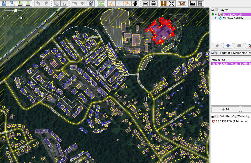
We taught volunteers how to use OSM’s Task Manager to load buildings and addresses, one neighborhood at a time, and made initial progress toward adding the data for the entire city into OpenStreetMap. There is still a lot of work to be done to get all the buildings and addresses loaded, so please join us for Part 2 of the effort Saturday, March 21st at the American Printing House for the Blind.
For this event there was actually zero programming needed. All that was needed is a laptop, following written and spoken instructions, and an attention to detail. Any other skills are just a bonus. It was a great way to build our brigade with some prep work by our leaders.
Outcomes
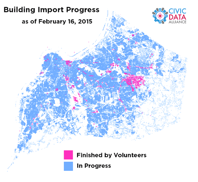
Between February 16 and May 15, 20+ people have collaboratively worked on over 550 areas of the city, for an estimated 410+ hours of work. We are now finished!
“This is simply amazing that it shows up so quickly. I am amazed to see the power of CDA and what a group of dedicated people can actually accomplish. It is amazing how much actually got done in one day. We can easily tell!” - Larry at APH
“I’m amazed! I was testing on a bus around the time the CDA added the data north of Brownsboro Rd, and when it showed up, I thought I was running the wrong build of our app. Should have checked my email before trying to confirm I was running the right build!” - Rob at APH
We also had some massive help from an expert OSM editor named Sam Wallingford, an engineering student at UVa. He started work in April and over the next month completed more areas than everyone else combined. Thanks so much Sam!
The CDA is looking at helping other brigades import their data, and may run a workshop this September. We are also prepping other city data to load, including parks and natural areas, streams, alleys, cemeteries, parking, and historic markers. We will continue to push the city to release more data to load, like traffic signs, traffic signals, 1-foot contours, parcels, and impervious surfaces.
CDA Work Before the Event
The core CDA put in about 140 volunteer hours to prep for the project and event. Here’s what we did. If your brigade were to do it, it would likely take 40 hours of prep with our guidance (please contact us for help!).
- Identify the need from APH during our December meetup.
- Work with LOJIC and Metro Louisville to add an appropriate open data license to portal and FTP site.
- Work with the OSM import community mailing lists to get approval for our import.
- Create OSM Wiki pages that show qualitative and quantitative data analysis, tagging, reconciliation plan, and user accounts process.
- Research the best methods for importing data properly into OSM: JOSM, Task Manager.
- Write a step-by-step Contributor Guide that can volunteers can follow, showing all scenarios
- Run geospacial analysis on the data to merge building footprints with address data.
- Create multiple OSM import files using a fork of existing code from NOLA’s import.
- Contact NOLA import lead to ensure our process and data is good.
- Create a Task Manager job after getting OSM admin access.
- Generate a JSON file with areas of the city broken into 575 census block groups for use in Task Manager.
- Core CDA members load some areas of the city in preparation for the event.
- Organize, promote, and run Code Across event with our wonderful attendees!
Tweets During CodeAcross Part 2
Over 40% of Louisville’s buildings/addresses are loaded into OSM thanks to you! Keep going: http://t.co/V746batQF4 pic.twitter.com/1IypkApRxN
— Civic Data Alliance (@CivicDataAlly) March 23, 2015#CodeAcross reprise w American Printing House for the Blind - public data infusion OpenStreetMap! @CivicDataAlly pic.twitter.com/1Jk7vaqFge
— Lazarus LLC (@LazarusLLC) March 21, 2015#CodeAcross part two has started at @APHfortheBlind http://t.co/mRoJuyNAok @codeforamerica pic.twitter.com/LwoA5xyXNB
— Civic Data Alliance (@CivicDataAlly) March 21, 2015Tweets During CodeAcross
Helping @APHfortheBlind to map Louisville, KY to assist blind pedestrians with @CodeForAmerica and @CivicDataAlly pic.twitter.com/HLJejvRmcT
— Dave Mattingly (@blackwyrm) February 21, 2015Collaborating and learning how to put buildings and addresses into Open Street Map.
Happy #CodeAcross! Civic hackers braved the wintry mix this morning to code for Louisville with @CivicDataAlly pic.twitter.com/tMl29O3M5E
— ladyson (@ladyson) February 21, 2015Resident Open Street Map expert Jeff McAdams (has the most edits in the city) discussing the details of our building import.
@CivicDataAlly @codeforamerica Louisville KY kicks off #CodeAcross to assist @APHfortheBlind ! pic.twitter.com/pfTgYQiEkp
— Chris Harrell (@TheHarrell) February 21, 2015Listening to Larry Skutchan from the American Printing House talk about how the data can help his Nearby Explorer app users.
Adding all buildings/address to @openstreetmap Louisville for @APHfortheBlind app @brianherbert @ladyson #codeaccross pic.twitter.com/2Q4m8Emb1F
Brian Herbert from Ushahidi (middle) lending his expertise, adding mapping data to Louisville.
Just made my first contribution to @openstreetmap ever here at #CodeAcross Louisville @CivicDataAlly pic.twitter.com/o2dKIlyvYu
— ladyson (@ladyson) February 21, 2015Results
Louisville’s buildings in vector 3D w/ @mapzen from our @APHfortheBlind import & live traffic! http://t.co/UVAOleRpOS pic.twitter.com/2bkvNlgUDN
— Civic Data Alliance (@CivicDataAlly) March 18, 2015Isometric 3D buildings showing up in @mapzen based on our @APHfortheBlind import. https://t.co/TfkulHcRoc pic.twitter.com/oQOSYKZDNi
— Civic Data Alliance (@CivicDataAlly) March 18, 2015With @LouGovIT buildings in OSM for @APHfortheBlind see shadows based on date and time. http://t.co/MyndMHmMPq pic.twitter.com/uby2ufIgVe
— Civic Data Alliance (@CivicDataAlly) March 13, 2015Now that Louisville has some OSM building data, you can view the city in 3D CAD software. https://t.co/v9DONbSm64 pic.twitter.com/d1sexRnyNK
— Civic Data Alliance (@CivicDataAlly) March 13, 2015Links to more info